My interests are in the field geodesy and remote sensing techniques like GPS, laser, gravimetry and radar to study the solid earth, seismic hazards and the cryosphere. Having many different observation methods makes the integration of different techniques an important part of current ongoing studies.
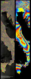
Sentinel 1a is a C-band Synthetic Aperture Radar with a repeat acquisition rate of 12 days. In combination with Sentinel 1b (estimated launch in 2016), the acquisition rate will decrease to 6 days (click here for more Sentinel 1 information). This high repeat rate together with the large illuminated tracks (200 km wide) make the Sentinel 1 constellation an attractive source of data to study the cryosphere and solid earth. An example Sentinel 1 interferogram over Italy is shown in Figure 1a (by NORUT and PPO.Labs, see http://insarap.org). This data is not continuous, but wrapped, were each color cycle represents 2.6 cm of displacement in the radar line of sight (LOS).
Unwrapping this correctly and the correction for tropospheric artefacts are two of the main challenges within the InSAR community. The high Sentinel 1 repeat rate does not necessary implies smaller atmospheric signals, as the atmosphere varies from day to day, and in space. In Figure 1b we demonstrate that the tropospheric correction estimated from the ERA-I (75 km) weather model outputs, from the European Centre for Medium- Range Weather Forecasts (ECMWF at http://www.ecmwf.int), shows promising results in reducing tropospheric arctifacts over a large region as imaged by Sentinel 1a. We find good agreement between the Sentinel 1a interferogram A) and our estimated tropospheric delay B) (e.g north-east region, south-west region, the volcanoes Etna and Vesuvius, and other locations). In general we find that the weather model is capable of estimating the long-wavelength features well. While the weather model is capable of estimating the magnitudes correctly, the timing and thus location in space might be off.
The problem of the troposphere will be further reduced in future, with a longer time-series of sentinel 1 acquisitions. These long-term observations together with tropospheric corrections will allow us to detect smaller magnitude surface deformations.
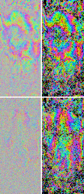
My current research focuses on the study of Slow Slip Events on the Mexican subduction zone by time-series radar interferometry (InSAR) techniques, example in figure. These events have been first observed by GPS and have since then been increasingly found mainly along subduction zones. My research emphasis is on the Mexican subduction zone, where Slow Slip Events have been observed by GPS with a high temporal occurrence, one approximately every four years for Guerrero, and where the earthquake equivalent magnitudes of the Slow Slip Events (~ Mw 7.6) are among the largest observed. It is not yet understood why the slip during these events occurs at such a snails pace. In subduction zones at least, it is hypothesized that pulses of water, released by water-rich minerals deeper within the subduction zone, increase the pore pressure as they pass through. The high pore pressure acts against the pressure from the overlying rock, unclamping the two sides of the fault, allowing slip to occur at lower stresses. Although this slow slip does not generate large seismic waves, it does cause an instantaneous elastic response in the surrounding rock, which results in deformation of the Earth surface, being observed by for GPS techniques [1-10] and InSAR techniques [11,12]. Unlike earthquakes slow slip events in themselves are not dangerous, but they change the stress-field, which can have implications for the occurrence of a potential damaging earthquake. Along the Mexican subduction, in the state of Guerrero, there is a seismic gap. While no earthquakes have occurred since 1911 (7.6 Mw) , slow slip studies over the region [1-12] have shown that slip partly extend into this region. This clearly indicates the importance of including slow slip events with those of past earthquakes in the study of seismic hazard.
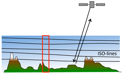
With the current progress of processing longer-swath SAR data and adjacent tracks, and moreover studying long wavelength deformation processes like slow slip events, the need for atmospheric correction becomes more important [13]. While the ionosphere becomes more persistent for the longer spatial wavelengths, like L-band, the troposphere affects the radar for all wavelengths. For InSAR it is mainly variation in height and space of water vapour that affects the radar signal, which can reach relative delays of up to 15 cm, making the much smaller tectonic signals. The dry delay, introduced by variation in pressure and temperature, is smaller but can still reach a couple of cm over long (> 100 km) tracks. This clearly indicates the need for an atmospheric correction. This can be done form external data, like weather model [14], GPS and spectrometer data [15,16], often limited by the lower spatial resolution of the auxiliary data. Another way is to estimate it from the InSAR data itself by filtering in space and time, which can be challenging when separating it from non-steady deformation, or by estimating it from the correlation between the interferometric phase and the topography in a non-deforming region [17] or by applying band filtering to find a band insensitive to deformation [18]. These methods assume the atmospheric properties not to vary spatially, which on the other hand can be significant for larger swaths. As part of my research we have been working on the development of a power law relation ship for the tropospheric delays that accounts for a spatially varying tropospheric signal that locally correlates between interferometric phase and topography [19].
| [1] |
Correa-Mora, F., C. DeMets, E. Cabral-Cano, O. Diaz-Molina, and B. Marques-Azua (2009), Transient deformation in southern Mexico in 2006 and 2007: Evidence for distinct deep-slip patches beneath Guerrero and Oaxaca, Geochem. Geophys. Geosyst., 10 (1), Q02S12, doi:10.1029/2008GC002211. |
| [2] |
Iglesias, A., S. Singh, A. Lowry, M. Santoyo,V. Kostoglodov, K. Larson, S. Franco-Sanchez, and T. Mikumo (2004), The silent earthquake of 2002 in the Guerrero seismic gap, Mexico (Mw = 7.6): inversion of slip on the plate interface and some implications, Geofisica Internacional, 43 (3), 309–317. |
| [3] |
Kostoglodov, V., S. Singh, J. Santiago, S. Franco, K. Larson, A. Lowry, and R. Bilham (2003), A large silent earthquake in the Guerrero seismic gab, Mexico, Geophys. Res. Lett., 30 (15), 1807, doi:10.1029/2003GL017219. |
| [4] |
Larson, K., A. Lowry, V. kostoglodov, W. Hutton, O. Snchez, K. Hudnet, and G. Surez (2004), Crustal deformation measurements in Guerrero, Mexico, J. Geophys. Res., 109, B04409, doi:10.1029/2003JB002843. |
| [5] |
Larson, K. M., V. Kostoglodov, S. Miyazaki, and J. Santiago (2007), The 2006 aseismic slow slip event in Guerrero, Mexico: New results from GPS, Geophys. Res. Lett., 34, L13309, doi:10.1029/2007GL029912. |
| [6] |
Lowry, A., K. Larson, V. Kostoglodov, and R. Bilham (2001), Transient fault slip in Guerrero, southern Mexico, J. Geophys. Res., 28, 3753–375. |
| [7] |
Radiguet, M., F. Cotton, M. Vergnolle, M. Campillo, B. Valette, V. Kostoglodov, and N. Cotte (2010), Spatial and temporal evolution of a long term slow slip event: the 2006 Guerrero Slow Slip Event, Geophys. J. Int., 184 (2), 816828, doi:10.1111/j.1365-246X.2010.04866.x. |
| [8] |
Radiguet, M., F. Cotton, M. Vergnolle, M. Campillo, A. Walpersdorf, N. Cotte, and V. Kostoglodov (2012), Slow slip events and strain accumulation in the Guerrero gap, Mexico, J. Geophys. Res., 117, doi:1 468 0.1029/2011JB008801. |
| [9] |
Vergnolle, M., A. Walpersdorf, V. Kostoglodov, P. Tregoning, J. Santiago, N. Cotte, and S. Franco (2010), Slow slip events in Mexico revised from the processing of 11-year GPS observations, J. Geophys. Res., 115, B08403, doi:10.1029/2009JB006852. |
| [10] |
Walpersdorf, A., N. Cotte, V. Kostoglodov, M. Vergnolle, M. Radiguet, J. A. Santiago, and M. Campillo (2011), Two successive slow slip events evidenced in 2009/2010 by a dense GPS network in Guerrero, Mexico, Geophys. Res. Lett., 38, L15307, doi:10.1029/2011GL048124. |
| [11] |
Bekaert, D. (2011), Insar time series analysis of the 2006 slow slip event on the guerrero subduction zone, mexico., M.S. thesis, Delft University of Technology, Delft, The Netherlands. |
| [12] |
Bekaert, D., and A. Hooper, E. Pathier and S. Yun (2010), InSAR time series analysis of the 2006 slow slip event on the Guerrero Subduction Zone, Mexico, American Geophysical Union, Fall Meeting 2010, G12A-03. |
| [13] |
Hooper, A., D. Bekaert, K. Spaans, and M. Arikan (2012), Recent advances in SAR interferometry time series analysis for measuring crustal deformation, 514517, doi:10.1016/j.tecto.2011.10.013. |
| [14] |
Wadge, G., P. Webley, I. James, R. Bingley, A. Dodson, S. Waugh, T. Veneboer, G. Puglisi, M. Mattia, D. Baker, S. Edwards, S. Edwards, and P. Clarke (2002), Atmospheric models, GPS and InSAR measurements of the tropospheric water vapour field over Mount Etna, Geophys. Res. Lett., 29, doi:10.1029/2002GL015159. |
| [15] |
Williams, S., Y. Bock, and P. Fang (1998), Integrated satellite interferometry: tropospheric noise, GPS estimates and implications for interferometric synthetic aperture radar products, J. Geophys. Res., 103, doi:10.1029/98JB02794. |
| [16] |
Puyssegur, B., R. Michel, and J. Avouac (2007), Tropospheric phase delay in interferometric synthetic aperture radar estimated from meteorological model and multispectral imagery, J. Geophys. Res., 112, B05419, doi:10.1029/2006JB004352. |
| [17] |
Wicks, C., D. Dzurisin, S. Ingebritsen, W. Thatcher, Z. Lu, and 491 J. Iverson (2002), Magmatic activity beneath the quiescent Three Sisters volcanic center, central Oregon Cascade Range, USA, Geophys. Res. Lett., 29, doi:10.1029/2001GL014205. |
| [18] |
Lin, Y., M. Simons, E. Hetland, P. Muse, and C. DiCaprio (2010), A multiscale approach to estimating topographically correlated propagation delays in radar interferograms, Geochem. Geophys. Geosyst., 11 (9). |
| [19] |
Bekaert, D., and A. Hooper (2011), A new algorithm for reduction of the tropospheric signal in InSAR data, applied to the 2006 slow slip event in Guerrero, Mexico, American Geophysical Union, Fall Meeting 2011, G22A-02. |


